
A Picture Is Worth A 1000 Words – Part III
Measuring Construction in Near Real-Time from Outer Space


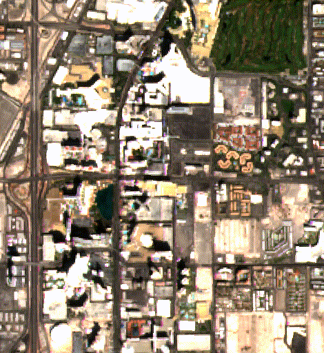
Time-lapse satellite imagery of Las Vegas reveals the expansion of the built environment in near real time—new construction, site preparation, and infrastructure growth visible months before appearing in official economic statistics from 2015 to 2026.
Fabulous Las Vegas – the city of gambling, goofing off, and perhaps, gauging economic activity.
Previously in A Picture Is Worth A 1000 Words, Part I and Part II, we explored both our key algorithm ROY (named after our founder’s grandfather), and our discovery of a Geospectral Signature that uniquely identifies each space and place by its reflective resonant imaging measurable from outer space.
Today, we return to ROY to explore what it is that Atlas Analytics’ is looking at in our proprietary satellite-based algorithms: the expansion of the built environment.
To this end, the GIF above is illustrative – using time-elapsed satellite imagery, we can literally see new buildings (including Vegas’ newest and grandest structure, The Sphere – notice the top right of our image) being erected in near real-time.
Why Construction?
We’re interested in construction—so let’s make this concrete.
We don’t need to measure the number of cars in Walmart parking lots when we can see that Walmart is building stores–the demand and growth is there. That construction represents real dollars being paid to the local populace in wages, and real dollars that are (partly) spent in the local economy.
Extrapolate this to other sectors of the economy. Increases in the service sector can be seen by construction of hospitals, hotels, and restaurants. Upzoning developed areas for increased housing density allows population growth, increasing a county’s tax base and labor pool.
The blue line shows headline U.S. GDP growth as reported by the federal government, while the red line reflects reported new housing units from the St. Louis Fed (FRED).
The chart above illustrates the relationship between a key component of the construction economy—new privately owned housing starts—and overall U.S. GDP growth over the past 25 years.
How Do We Measure This Change?
There’s an old aphorism: “Cranes in the air, buyer beware.”
But what if you could measure the growth of an area – before the cranes appeared.
The construction of a building has substantial economic impact. Heavy equipment must be transported to the site, land prepared, and foundations poured. Framing follows, then roofs, windows, and doors, before interior build-out, landscaping, parking, and road improvements complete the process.
Each of these steps leaves a distinct multispectral footprint—changes in surface reflectance, material composition, shadow geometry, and activity density—that we observe continuously through satellite imagery.
Because these signals emerge before construction is completed—and often before it is officially reported—they allow us to detect inflection points in local and national economic growth well ahead of traditional statistics.
What It Means for You?
Atlas Analytics measures real economic activity before it appears in official statistics. By observing construction and physical expansion directly from space, we generate signals ahead of government data releases—often weeks or months earlier.
That timing matters. Markets move on expectations, not confirmations. Early visibility into economic inflection points provides meaningful informational advantage to investors, policymakers, and institutions.
We use these signals internally as well. Between November 1, 2024 and November 1, 2025, Atlas strategies informed by this data generated a 54% return.
We publish these insights weekly—translating satellite-derived signals into actionable macro views for investors and institutions. Contact us to learn more.

 | A guest post by
|
 | A guest post by
|